How to customize your locations map
YMCA Website Services includes robust mapping functionality defined in the
openy_map subproject. Maps typically are displayed on the /locations page using the
Location Finder component and are highly customizable.
These are a few common customizations:
Changing Map Options
By default, content types have these labels on the map:
- Branch = YMCAs
- Camp = Camps
- Facility = Facilities
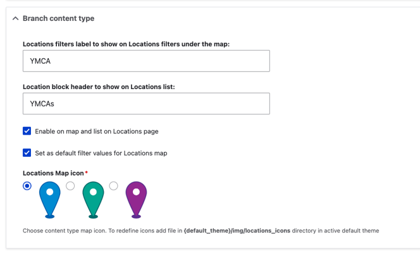
These labels can be customized in the Drupal administration pages to better suit your YMCA’s more member-focused terminology. To do so:
- In the Admin Menu, go to YMCA Website Services (or Open Y on prior versions) > Settings > Map Settings
- In the Branch/Camp/Facility Content Type sections you can:
- Edit each content type as needed then Save the form.
- Reload
/locationsand you should see your changes.
Adding Additional Location Types
You can add new content types to the map with a few steps. This may require some trial and error, so be sure to work in a testing environment first. You will need to have the Field UI module enabled to do this through the Drupal admin UI.
- Create a new content type via Structure > Content types > Add content type
- Add these existing fields to the content type:
field_location_coordinates- requiredfield_location_addressandfield_location_phone- suggested for display on the map and location teasers.field_location_amenities- if the location should be searchable with the Amenities search.
- Set up the Teaser display on the new content type:
- Navigate to Manage display then Teaser
- Update these settings to match the Branch Teaser display at
/admin/structure/types/manage/branch/display/teaser
- Go back to the Map Settings at
admin/openy/settings/openy_mapand configure the options for your new location type.

